The tides are the breath of the ocean; understanding them is about more than just knowing when high water is; it’s about efficiency, safety, and making sure you always have water under your keel. For sailors used to the steady levels of Lake Zurich, Lake Zug or Lake Geneva, the massive tidal ranges of the Atlantic can be a shock. Understanding tides is one of the single biggest steps in converting your lake skills into offshore competence.
For those who want a refresher—or if you missed our recent talk on tides—here is a summary of the key concepts we covered.
Why Tides Matter
Tides affect us in two ways: vertically (height) and horizontally (stream/current).
- The Positive: They provide “free horsepower” when the stream is with you and allow access to shallow harbours at high water.
- The Negative: They can leave you high and dry if you miscalculate, slow you down if you fight the current, or create dangerous sea states like “wind-over-tide”.
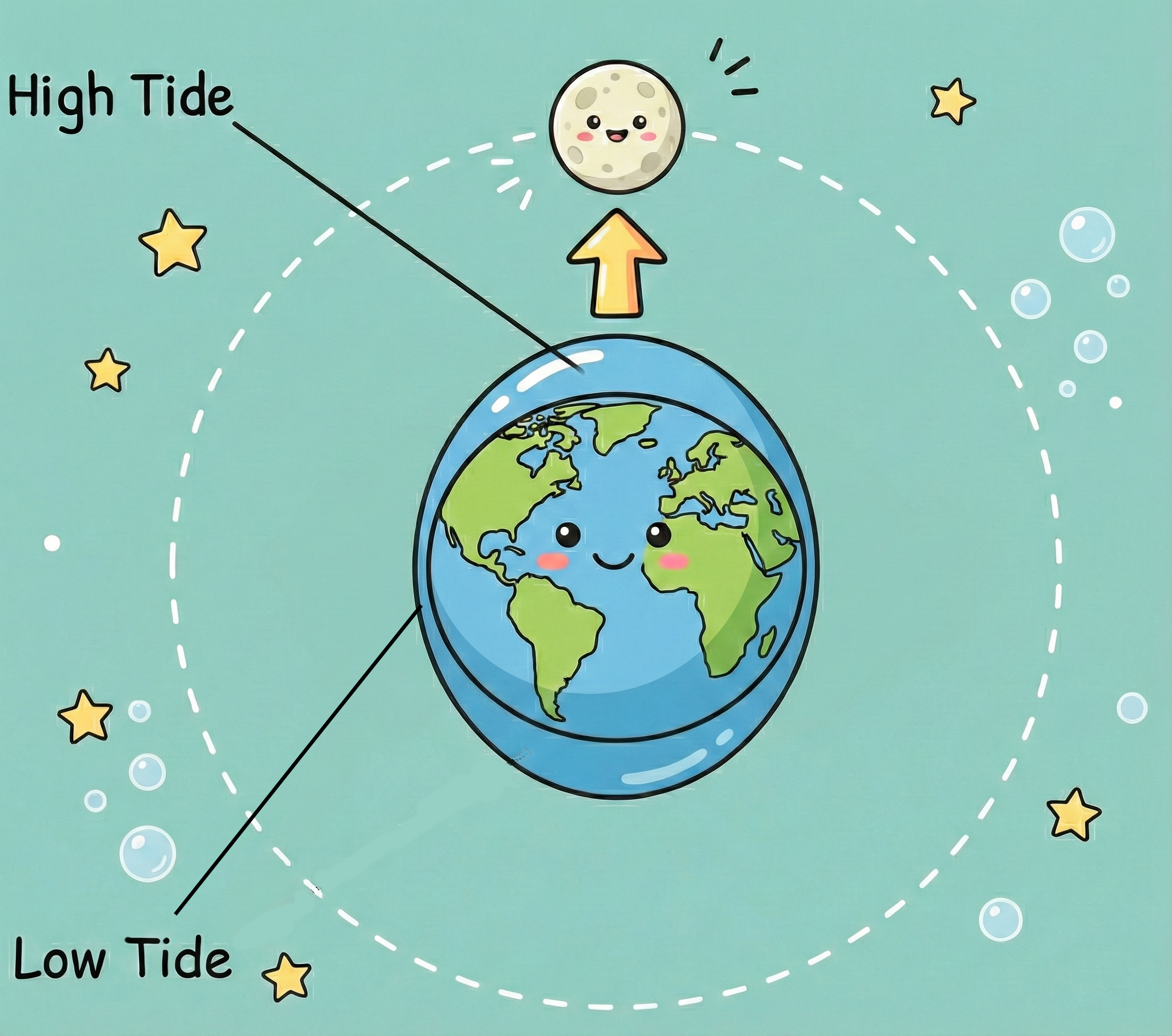
What Causes Tides? (The Earth, Moon & Sun)
Tides are essentially a tug of war between the Earth, Moon, and Sun.
- The Primary Driver: The Moon has the biggest influence because it is closer to Earth. Gravity pulls the water into a “bulge” on the side facing the Moon, and then pulls the Earth into this bulge, leaving a corresponding high-tide bulge on the far side of the planet.
- The Sun’s Role: While less powerful than the Moon regarding tides, the Sun reinforces or counteracts the Moon’s pull depending on their alignment.
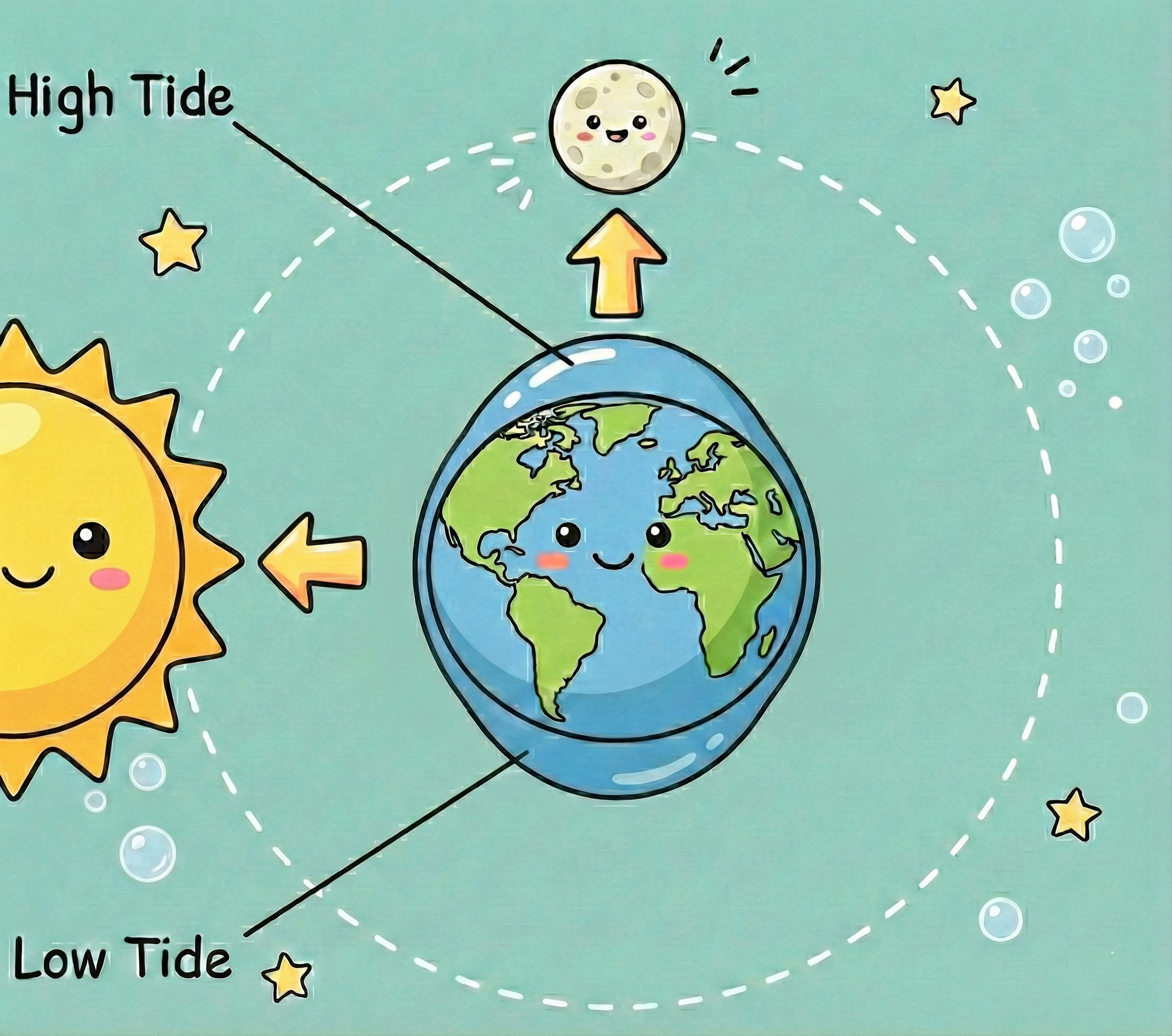
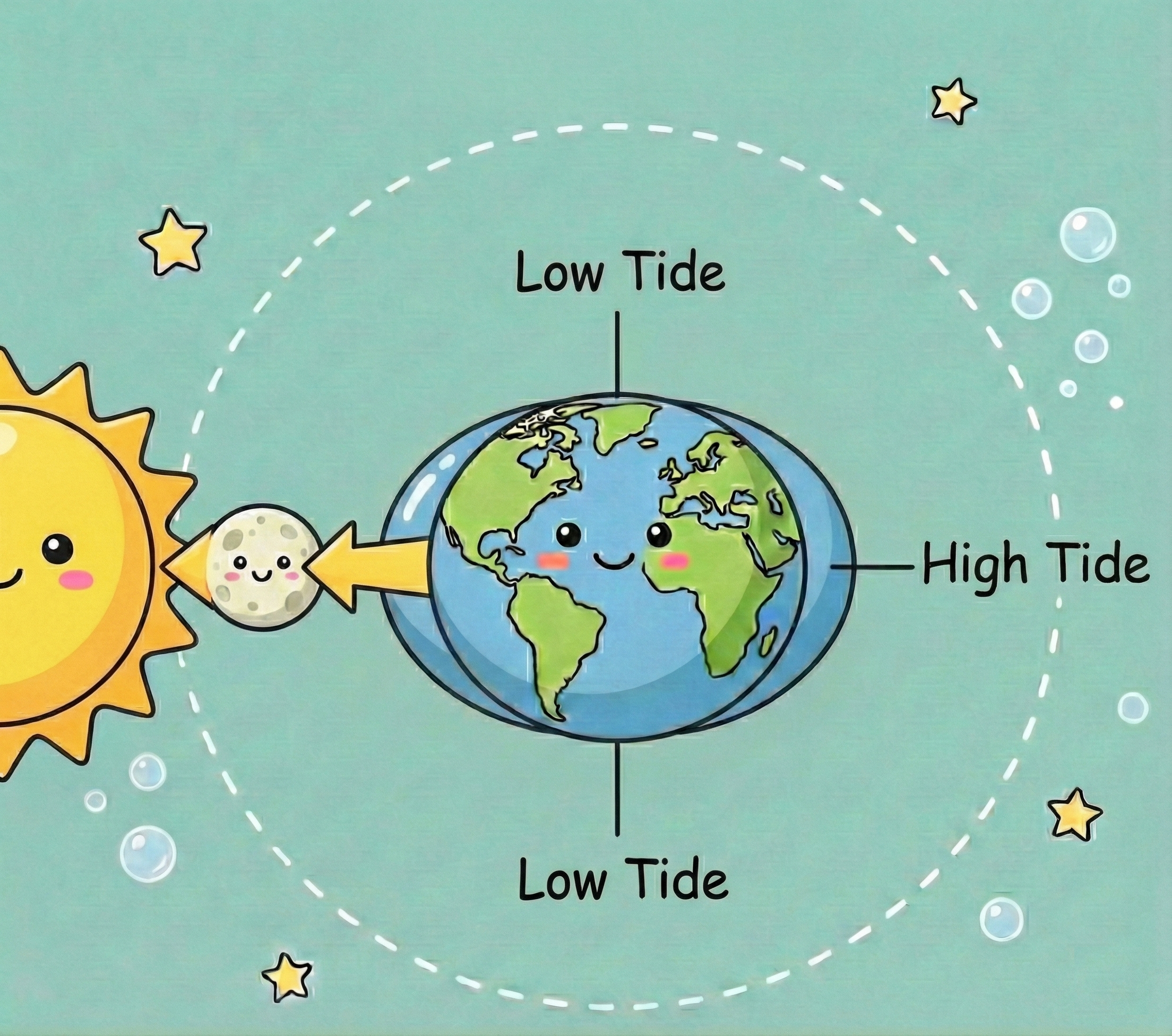
What is the difference between Spring and Neap Tides?
Understanding the phase of the moon is your first step in predicting the tidal range.
- Spring Tides (Big Range): Occur at New Moon & Full Moon. The Sun, Moon, and Earth line up, combining their gravity to create higher highs and lower lows.
- Neap Tides (Small Range): Occur at the Quarter Moons. The Sun and Moon are at 90° to each other, partially cancelling out their forces. This results in lower high tides and higher low tides.
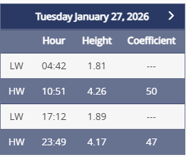
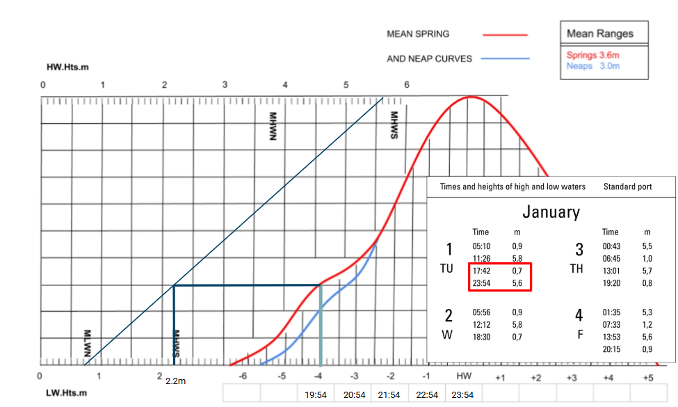
Tide Tables
Tide Tables are published by most ports (or can be looked up online) and contain the information of High and Low Water and the tidal heights of both High and Low Water. Be careful with the times as they are usually in the local times and do not adjust for “summer time”. In the summertime, you may have to add an hour to get the correct time.
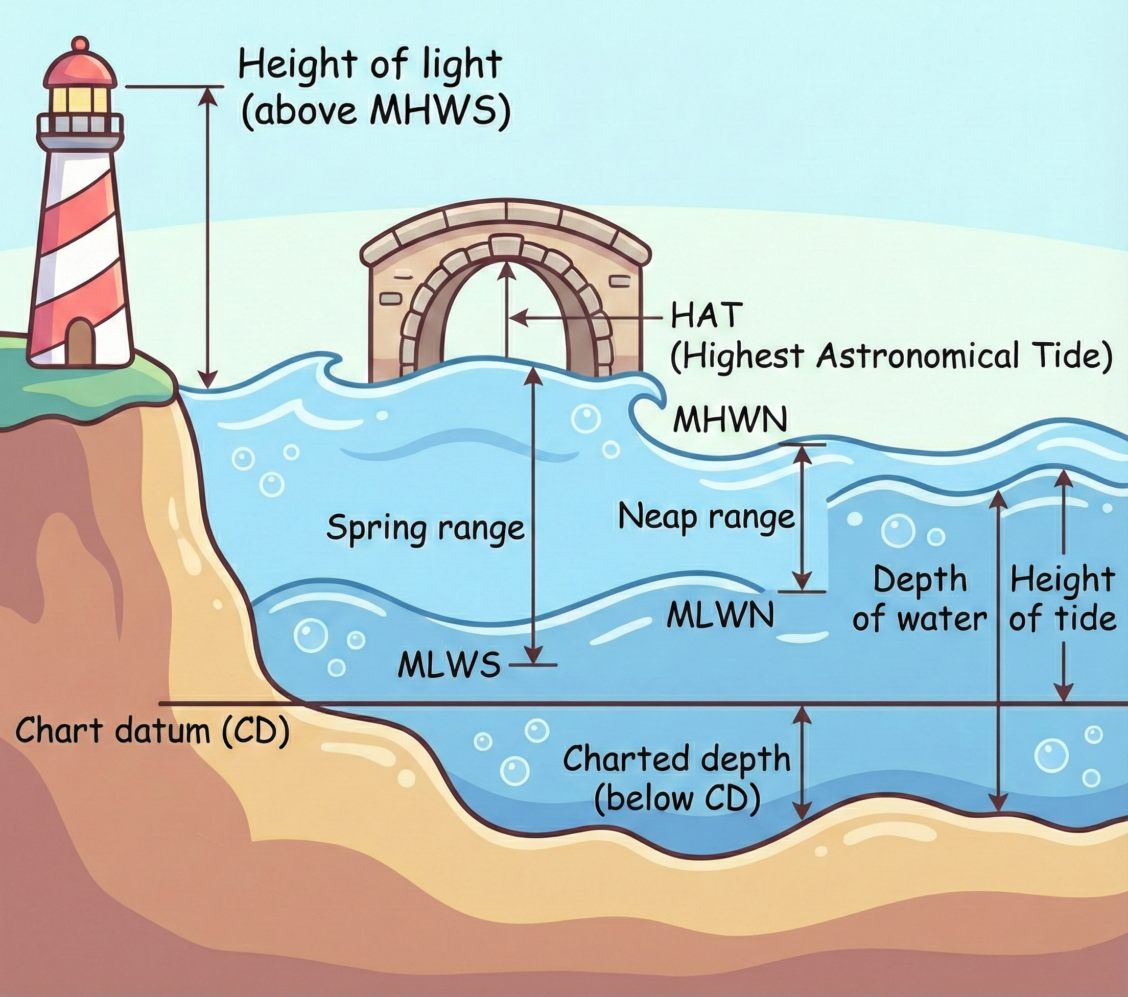
Navigation Essentials: Height & Depth
When planning a passage, remember that charts use Chart Datum (CD), which is usually the Lowest Astronomical Tide (LAT)—the lowest the tide is predicted to fall under average conditions.
- The Formula: Actual Depth = Charted Depth + Height of Tide.
- Drying Heights: Watch out for underlined numbers on the chart; these are rocks or banks that dry out at LAT.
Glossary of Essential Tidal Terms
- LAT: Lowest Astronomical Tide (lowest possible tide under normal meteorological conditions)
- Chart Datum: Depth of Water (or Drying Heights) at LAT.
- MHWS/MLWS: Mean High/Low Water Springs
- MHWN/MLWN: Mean High/Low Water Neaps
- Spring Range (average): Is the range between MHWS and MLWS
- Neap Range (average): Is the range between MHWN and MLWN
- Depth of Water: Tidal height + Depth Below Chart Datum or Tidal Height – Drying Height
- HAT: Highest Astronomical Tide (Highest tide possible under normal meteorological conditions. Clearing height under bridges are from HAT)
- Height of Light: Height of the light signal above MHWS
The Rule of Twelfths (How to calculate tidal heights?)
For semi-diurnal tides (like we have in Europe/Atlantic), the tide doesn’t rise at a constant speed. It follows a bell curve. To estimate the height at a specific hour, use the Rule of Twelfths:
1st Hour: Rises 1/12th of the range
2nd Hour: Rises 2/12ths of the range
3rd & 4th Hours: Rises 3/12ths (max flow)
5th Hour: Slows to 2/12ths
6th Hour: Finishes with 1/12th
Note: The Rule of Twelfths is an estimation for semi-diurnal tides and should not replace official tide tables for critical clearance
Rule of 12ths Calculator
Estimate tidal height between High and Low water.
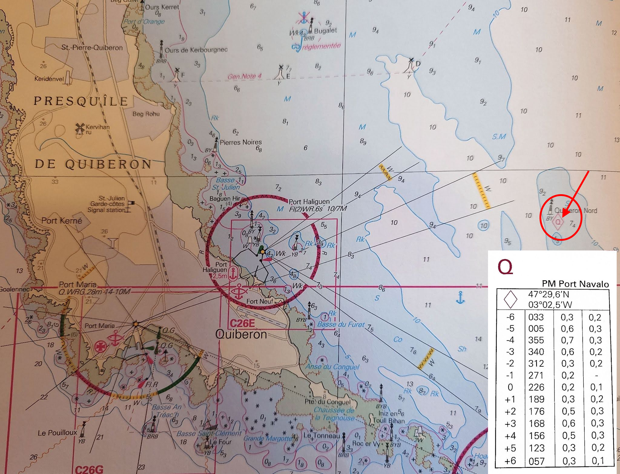
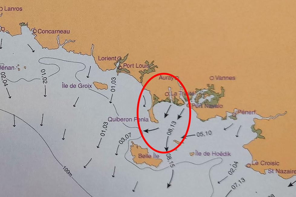
Tide vs. Current: Understanding Tidal Streams
Never ignore the current. Tidal streams can significantly alter your ETA and safety.
- Tidal Diamonds: Look for the magenta diamonds on your chart. These refer to a table giving you the “Set” (direction) and “Rate” (speed) of the current for each hour relative to High Water.
- Tidal Atlases: Visual guides with arrows. Thicker arrows mean stronger currents. Remember that numbers like “12, 23” on these charts often mean 1.2 knots at Neaps and 2.3 knots at Springs.
Meteorological Effects
Meteorology: Tide tables are based only on the movements of celestial bodies (astronomy). They cannot predict the weather. Real-time conditions can change the water level significantly:
- Air Pressure: High pressure pushes down on the sea surface, lowering the water level. Low pressure (depressions) allows the water to rise. A difference of 30 hectopascals can change the sea level by ~30cm (one foot).
- Wind: (Storm Surges): Strong, sustained winds blowing onshore can “pile up” water, creating higher-than-predicted tides. Conversely, offshore winds can push water away, resulting in unexpectedly low tides—a danger for shallow moorings.
Dangers to Watch For
- Wind over Tide: When the wind blows against the tidal stream, it creates steep, choppy, and dangerous waves.
- Tidal Races & Overfalls: Fast water squeezed around headlands or flowing over uneven seabeds can cause turbulence. Avoid these when the tide is running hard.
Summary
Safe navigation relies on understanding these cycles. Know your Moon phase (Springs vs. Neaps), check your stream (diamonds and atlases), and always ensure you have enough water under the keel (Rule of Twelfths).
Want to put this into practice or learn more? Join us on one of our activities this coming summer.
Spring tides are tides with the greatest range between high and low water, occurring twice a month at the new and full moon.
Neap tides are tides with the least range between high and low water, occurring twice a month at first and third quarters of the moon’s cycle.
Spring Tides occur twice in a lunar month at full and “new” moons. If you see a full moon or no moon in the sky it is probably spring tides (providing the moon should have already risen!)
For semi-diurnal tides (like we have in Europe/Atlantic), the tide doesn’t rise at a constant speed. It follows a bell curve. To estimate the height at a specific hour, use the Rule of Twelfths:
1st Hour: Rises 1/12th of the range
2nd Hour: Rises 2/12ths of the range
3rd & 4th Hours: Rises 3/12ths (max flow)
5th Hour: Slows to 2/12ths
6th Hour: Finishes with 1/12th
No, the rule of 12ths only applies to semi-diurnal tides. That is two high and low tides of similar heights in a 24-hour period. Areas with other types of tides (i.e. only 1 high or low per day, or 2 different height highs and lows) don’t fit the rule of 12ths very well.
Areas where the tidal flow is substantially influenced by the narrowing of land masses, such as around islands (Solent, Isle of Wight) or where the water has to travel through a narrow opening (the Mediterranean), also don’t work very well with the rule of 12ths.
Air pressure itself does not influence the “tide” (i.e. the movement of water due to the lunar cycle), but it does affect the water level. Low pressure raises the water level, and high pressure drops the water level. Therefore, an astronomical high tide predicted at a certain height will actually be higher if it’s very low pressure; likewise, it will not be quite as high as predicted if the pressure is very high.
Wind blowing onshore or offshore can also influence the measured height by forcing water up or away from the coast. (This effect is sometimes known as a storm surge, but storms are formed by low pressure systems, so there is, in fact, a double effect of raising the water level when storm surges occur.)
For the RYA Yachtmaster exams (Coastal and Offshore), tidal waters refer to any waters where tidal data is published and is likely to have enough of an effect on your passage that its influence has to be taken into account when planning.
This includes the coasts of Ireland and England, Atlantic Europe, the Canary Islands and parts of the Caribbean (amongst other places). It does not include the Mediterranean or the Baltic Sea.
No responses yet