If you’re planning a yacht charter in Croatia, you’re probably dreaming of 15 knots of steady Maestral wind, flat seas, and cold beers at anchor. And 90% of the time, that’s exactly what you get.
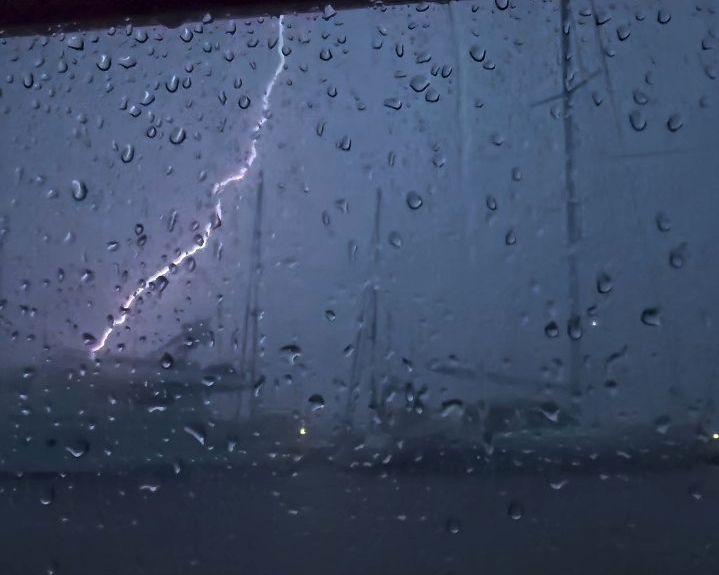
But then there is the Nevera (or Neverin).
If you learned to sail in the UK or Northern Europe, you know about cold fronts. A Nevera is Dalmatia’s highly localised, violently explosive version of that. It’s a summer thermal thunderstorm that lasts maybe 15 to 45 minutes, but the peak intensity is staggering. We are talking about wind jumping from zero to 50+ knots in less than five minutes, accompanied by a 10-degree temperature plunge, horizontal rain, and occasional hail.
Local guidebooks often tell charterers to “watch out for dark clouds in the west.” I’m going to be blunt: if you wait until you see the terrifying, dark roll-cloud scraping across the Adriatic, you are already out of time.
At All Winds Adventures, safety is our absolute baseline. Whether you are chartering our Oceanis 41.1 or just sailing the archipelago on your own, here is the insider, pro-skipper guide to predicting, evading, and surviving a Nevera.
1. How to Predict Dangerous Weather when Sailing in Croatia (Before the Clouds Form)
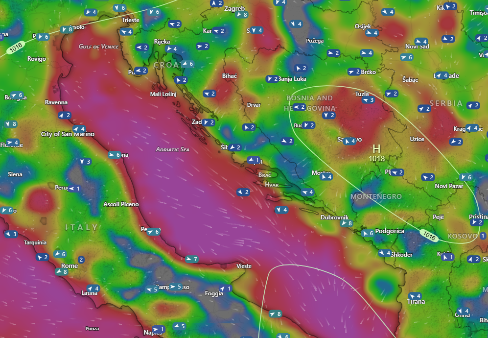
You cannot predict a Nevera by looking at the sky in the morning. You need to look at the raw data a day in advance using apps like Windy and DHMZ (the Croatian Meteorological site).
- Look for the “Barometric Swamp”: A Nevera loves a stagnant, sweltering weather map. If the pressure is high (1020+ hPa), with the normal thermal winds in the afternoon, you’re usually fine—that high pressure acts as an invisible lid, suppressing storms. But if you have a “flat gradient” with lower pressure (around 1010 hPa), that lid is gone. The sun bakes the sea, the humidity spikes, and the atmosphere turns into a pressure cooker. You can feel the weight of the air, and it feels clammy and difficult to breath.
- Check the CAPE Index: On Windy, turn on the CAPE (Convective Available Potential Energy) layer. This is the explosive fuel in the atmosphere. If it’s a windless, 35°C day and you see a CAPE forecast of 1500+ J/kg (or especially >2200 J/kg) in your general area, you might be sitting on a loaded spring.
- The Spark: The final trigger is usually a distant, weak low-pressure system rolling over the Alps, or the mountains of the coast themselves. Anything that sends a ripple of cold air high above the Adriatic’s hot “swamp.” When those air masses meet, the hot air violently shoots upward, creating a massive surface vacuum that sucks in a 50-knot gust front. If there is any kind of temperature change (also in the higher atmosphere then this can lead to the high potential energy in the CAPE being released. Remember CAPE is not the likelihood of a storm occurring; it’s how much energy it might have if it does occur.
2. Evasion: Plan to Shelter Early
The absolute best way to survive a Nevera is to be tied up when it hits. If your weather app shows high CAPE, a flat gradient, and a thunderstorm risk, do not wait to see what happens. Change your itinerary. Aim to be securely anchored or on a secure mooring buoy by 3:00 PM.
- Hide on the East: Neveras almost universally strike from the West, Northwest, or Southwest (rolling off the Italian coast). Avoid anchoring on the exposed western shores of the islands. You want deep bays on the eastern or northern shores where high island peaks to your West will physically break the wind.
- Holding is Everything: In 50 knots of wind, mud and dense sand are your best friends. A gorgeous bay with a rocky, weed-covered bottom is a trap. If your anchor can’t dig deep, you will drag, no matter how sheltered the bay looks on the chart.
High Cape and a forecast for Thunder over the mountains do not necessarily mean a Nevera will form. Yes, there is likely to be a thunder event, but this is most likely to be centred over the mountains of the mainland. You might be able to stay further out in outlying islands and avoid the thunder entirely, or enjoy the show from a distance.
3. The Golden Rule: Lines Out of the Water
Whether you get caught at sea or at anchor, do this immediately: Pull in every single trailing rope, sheet, and mooring line. If a loose line washes overboard and wraps around your propeller, you have instantly lost your engine. In a Nevera, your engine is your only lifeline. Without it, you are drifting helplessly toward the rocks. Clear the decks immediately.
4. Caught at Sea: The Open Water Protocol
If you are underway when the sky goes dark and the temperature plummets, shift into survival mode.
- Forget “Sea Room”: Textbooks tell you to run before the storm. In Croatia, charterers are usually limited to a 12-mile offshore limit, and the sea is an obstacle course of islands and reefs. You will run out of sea room fast.
- Hold Station: If you can’t outrun it, use geography to your advantage. Motor to the leeward (downwind) side of the highest nearby island. Keep the bow pointed into the wind and feather the throttle to hold your position. The water will stay relatively flat even if the wind is howling over the hills above you.
- Kill the Bimini Kite: A bimini in 50 knots is a parachute trying to rip your fiberglass deck apart. Fold and strap it down. (Skipper’s Note: If you are sailing our Oceanis 41.1, ‘All Winds’, leave the sprayhood up! It is aerodynamically built to take the wind and will save the helmsman from being blinded by horizontal rain).
5. Caught at Anchor: The Nightmare Scenario
You are in a bay. The white water is rushing toward the boat. You have about 30 seconds.
- Engine ON: Start the engine immediately. Do not wait for the wind to hit.
- Motor into the Load: Put the boat in forward gear and slowly motor directly into the wind. You aren’t trying to sail away; you are acting as a shock absorber to take the massive, snapping strain off your anchor chain and windlass.
- The “Slip and Run”: If your anchor pops out and you start dragging toward the rocks, do not try to pull up 50 meters of chain in a howling gale. Tie a fender to the bitter end of your chain, dump the whole thing overboard, and steer out of the bay into open water. You can come back and retrieve your tackle when the sun comes out.
6. Crew Boss: Managing the Humans
A skipper’s ultimate test isn’t steering the boat; it’s managing the people onboard. Panic is highly contagious. So is calm.
- Cockpit Only: The foredeck is completely off-limits. Get everyone into the cockpit, the deepest and safest part of the boat.
- Lifejackets & Tethers: Lifejackets go on. If you have jacklines, clip in. This completely removes the terrifying “man overboard” scenario from your mental load, allowing you to focus 100% on the helm.
- Manage the Nausea: Keep non-essential crew in the cockpit, tucked low behind the sprayhood, looking at the horizon. Sending a nervous guest into the saloon during a violent squall is a guaranteed recipe for severe seasickness.
- Give Them a Job: The temperature drop will make guests shiver, which amplifies panic. Throw foul weather jackets at them and give them a simple job, like “keep your eyes on that catamaran to our port side.” Speak in a normal, low voice. If you look bored and in control, they will trust you.
Quick-Response Protocol: Managing a Croatian Nevera
A Nevera is a violent summer squall line delivering sudden straight-line winds of 50+ knots. Use this checklist to mitigate danger:
| Risk Factor | Tactical Action | Pro-Skipper Implementation |
|---|---|---|
| Propeller Fouling | Lines out of the water | Pull all trailing ropes, sheets, and dinghy painters on deck immediately. |
| Structural Damage | Secure the canvas | Drop and secure the bimini. Leave the aerodynamic sprayhood up for helm shelter. |
| Forecast Errors | Model Consensus | Check DHMZ’s ALADIN model alongside ECMWF/ICON. Look for worst-case consensus. |
| Anchor Strain | Relieve the windlass | Engine ON. Motor slowly into the straight-line winds to act as a shock absorber. |
| Dragging Emergency | Execute a clean slip | Let chain run to the bitter end, lash a fender at the bow roller, and cut the nylon lash. |
| Crew Safety | Prevent MOB scenarios | Lifejackets ON. Keep crew in the cockpit and give them a simple visual monitoring job. |
Note: While the checklist above may help to keep you safe, surviving a sudden 50-knot gust requires understanding your boat, the triggers and how to manage the situation should you get caught. With this article, we hope to give you a little more information to help keep you safe.
Explore the Adriatic with All Winds Adventures
A Nevera is a fierce reminder of nature’s power, but with proactive seamanship and the right preparation, it is a completely manageable event that passes as quickly as it arrives.
At All Winds Adventures, we pair local, real-world experience with top-tier vessel preparation:
- Charter All Winds Directly: Our beautifully maintained Beneteau Oceanis 41.1 is available for private charter bookings out of our base in Croatia.
- Worldwide Charter Brokerage: Planning a holiday somewhere else in the Ionian, Adriatic, or Tyrrhenian seas? As an independent charter agency, we source quality boats worldwide at competitive rates, managing the fleet logistics for you.
- Sailing & Windsurfing Coaching: From refining your skills closer to home on the Swiss Lakes (Zug/Zurich) to intensive skipper training weeks in the Mediterranean, we help you build practical, real-world capability.
A Nevera is a highly intense but short-lived convective event. The absolute peak intensity of the straight-line winds and horizontal rain typically lasts between 15 and 45 minutes before the cell passes and the conditions stabilise.
Standard weather apps with generic cloud and rain icons often fail to predict exactly where a localised Nevera will pop up. Instead of looking at simple rain icons, you must actively track the atmospheric energy using the CAPE index and watch the radar or precipitation layers on Windy during the day to spot cells forming spontaneously in the afternoon heat.
If your ground tackle breaks traction and the vessel begins dragging rapidly towards hazards, do not try to winch up the chain against a 50-knot gale, as you risk burning out the windlass or injuring your crew. Instead, let the chain run out entirely to its bitter end, secure a large floating fender directly to the chain at the bow roller, and use a sharp knife to slice the nylon safety lash in the chain locker to execute a clean slip.
Yes, the thermodynamic principles that trigger an Adriatic Nevera occur right across the Mediterranean. A tragic example occurred on 18 August 2022 off the northwest coast of Corsica, where a sudden convective squall line delivered hurricane-force downbursts of up to 121 knots, capsizing and grounding numerous vessels.
Exactly two years later, on 14 August 2024, a similar intense summer convective system (known locally in Spain as a DANA or Gota Fría) hit the Balearic Islands. The storm brought sudden 60-knot straight-line winds and a rapid lee-shore swell to Mallorca and Formentera, catching dozens of crews completely by surprise and forcing a significant number of charter boats and luxury yachts hard aground on the beaches and rocks.
More recently, in June 2025, we saw the exact same mechanism unfold when a violent convective system developed over northern Italy and raced across the northern Adriatic. It slammed directly into the western coast of Istria, catching unsheltered crews out and driving roughly 30 yachts aground in the areas surrounding Rovinj and Poreč with recorded wind speeds exceeding 110 km/h. These incidents serve as a clear reminder that sudden, severe convective windstorms are a broader Mediterranean reality, not just a Croatian phenomenon.
The common complaint that a Nevera “came out of nowhere” usually stems from a misunderstanding of how convective weather works. Standard weather apps rely on automated icons, which struggle to show exactly where a highly localised, isolated thermal cell will drop its wind. If a skipper only looks for a little thunderstorm icon on their screen, they will frequently be caught out.
However, while the exact micro-location of a downburst cell is unpredictable, the necessary ingredients are highly visible hours or days in advance. By actively monitoring the broader meteorological data—watching for a stagnant “barometric swamp” layout, a sharp spike in the hourly CAPE timeline, and the arrival of a high-altitude cold trigger—you can easily recognise when the atmosphere is primed for an event. Good seamanship means identifying these ingredients early, shortening your sailing window as a precaution, and using live radar tracking to stay ahead of the elements. The sea always commands humility and can surprise even the most prepared crew, but by reading the atmospheric ingredients rather than just relying on generic app icons, you dramatically stack the odds in your favour.
No responses yet