Bridge the Gap Between Sailing School and Sea
Booking your first charter is exciting, but it comes with questions. Will I be able to dock? How do I handle the check-in? What if the anchor drags?
At All Winds Adventures, we don't care about gold bars on your epaulettes. We care about good seamanship. We are Sailing Coaches, not just booking agents.
We have curated our best advice into this step-by-step guide to help you transition from 'crew member' to 'Skipper in Command'.
Bookmark this page—it is your virtual mentor.
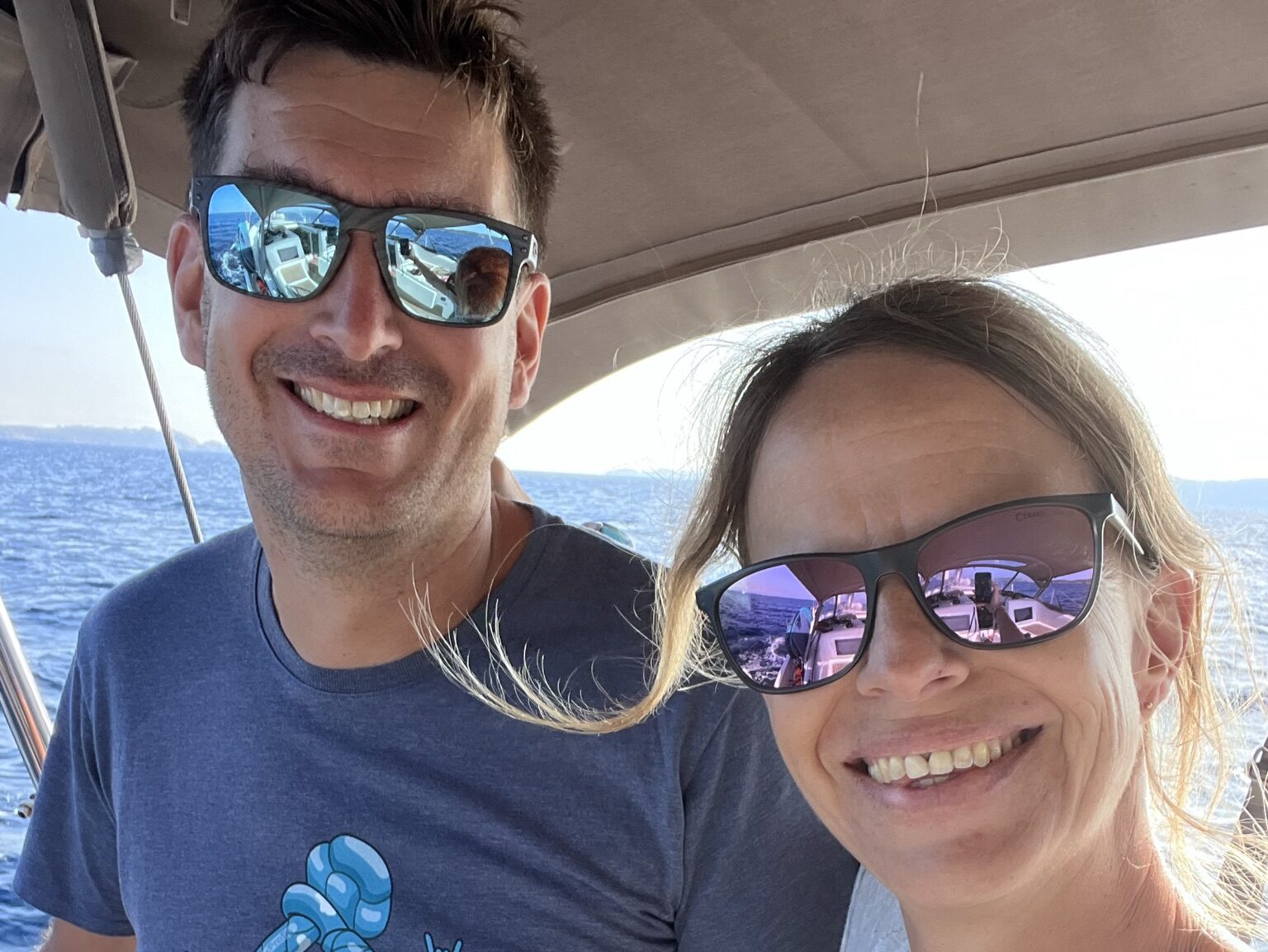
Karin & Dave
Founders All Winds Adventures
Stop Following Fixed Itineraries
The secret to a stress-free charter isn't a perfect itinerary—it's the ability to make a sound decision when the weather changes. We advocate for a 'Weather-First' philosophy. Instead of forcing a route, use the Go/No-Go Decision Tool below. It’s a professional-grade risk matrix tailored for skippers to help you decide when to sail and when to stay in the bay with a cold drink.
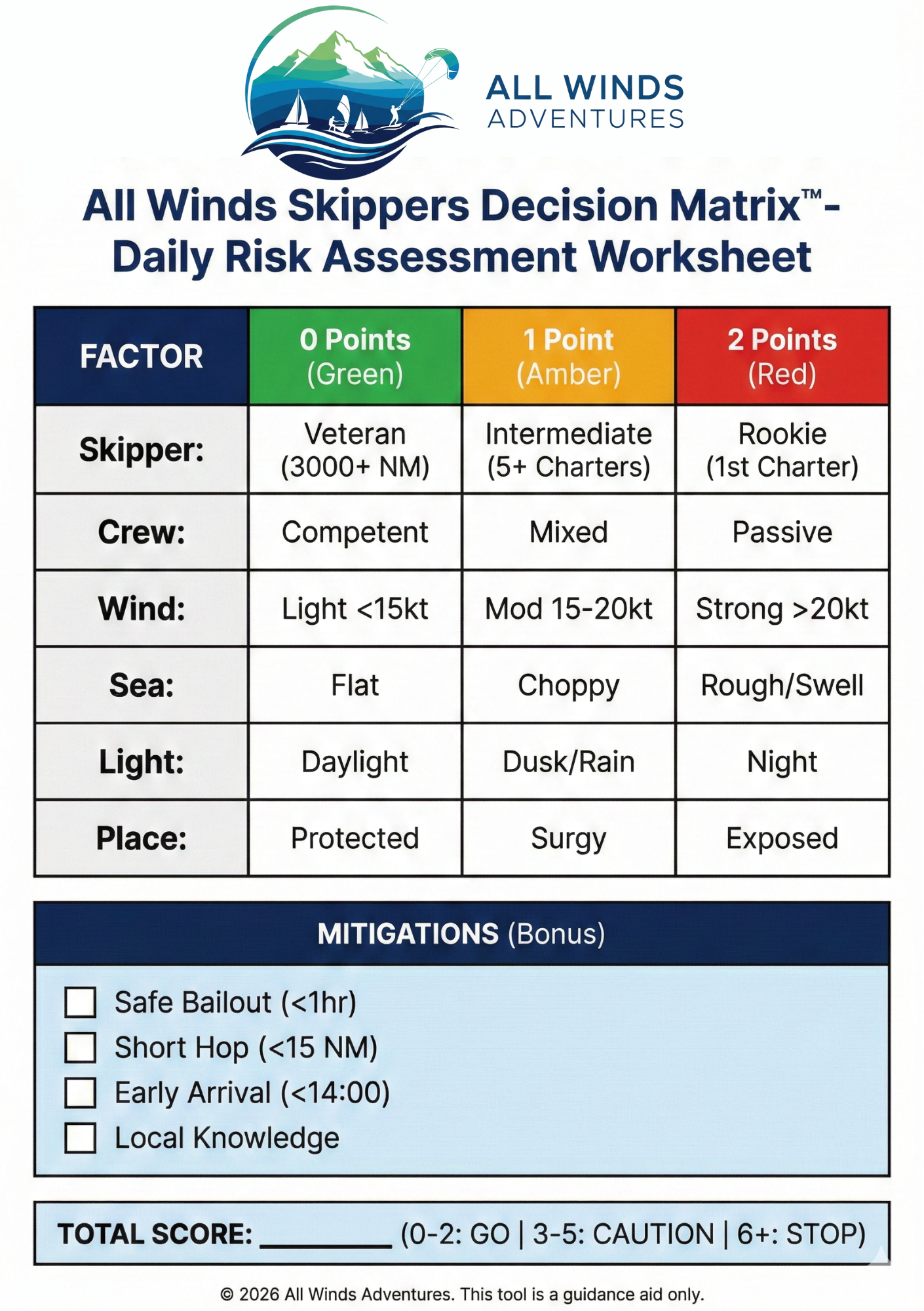
The "Go/No-Go" Decision Tool
Good seamanship isn't just about handling the boat; it’s about making the right call before you even untie the lines
We developed this Risk Assessment Matrix to help you objectify your decision-making. It takes the "gut feeling" out of the equation and gives you a calculated risk score based on three critical factors: The Human Factor (Who is on board?), The Environment (What is the weather doing?), and The Destination (Is it safe to stay here tonight?)
How to use this tool:
Be Honest: The sea doesn't care about your ego. If you are a new skipper, select "Rookie." If your crew is tired, mark them as "Passive."
Check the Traffic Light:
🟢 Green: Conditions are within your team's comfort zone.
🟡 Amber: Risks are present. You need a solid "Plan B" and to brief your crew carefully.
🔴 Red: The complexity exceeds your team's current capacity. Stay in port or choose a safer, shorter route.
All Winds Skippers Decision Matrix™
Honest input = Safe Sailing.
1. The Human Factor
Skipper
Crew
2. The Environment
Wind
Sea State
Visibility
3. The Destination
Protection
4. Safety Factors (Bonus)
Safe Alternates<1 hr away
Short Hop<15 NM
Daylight BufferArrive by 14:00
Local KnowledgeKnows port
Select All OptionsComplete the matrix above.
The Skippers Toolbox
Execution is everything. We’ve built these interactive tools to handle the heavy lifting of navigation and boat management. From calculating your tide-adjusted 'Course to Steer' to checking your anchor scope, these tools turn your smartphone into a professional navigation station.
We’ve digitised the chart table. Use these interactive calculators to handle your tidal heights, course corrections, and safety checks in seconds.
All Winds Matrix (to Download)
How to save this card:
Desktop: Right-click on each image and select "Save Image As..." to download.
Mobile: Long-press on the image and select "Add to Photos" or "Download Image."
Print Settings: For best results, print double-sided on A5 cardstock and laminate for waterproofing.
Need a durable copy? We have professionally printed, waterproof versions of this card available for our charter guests. Contact us to request a hard copy for your next trip.
⚠️ Skipper's Disclaimer: This tool is a decision-making aid only. It does not replace official weather forecasts, nautical charts, or the Skipper's own judgement. The decision to leave port and the safety of the vessel and crew remain the sole and exclusive responsibility of the Skipper.
© 2026 All Winds Adventures.
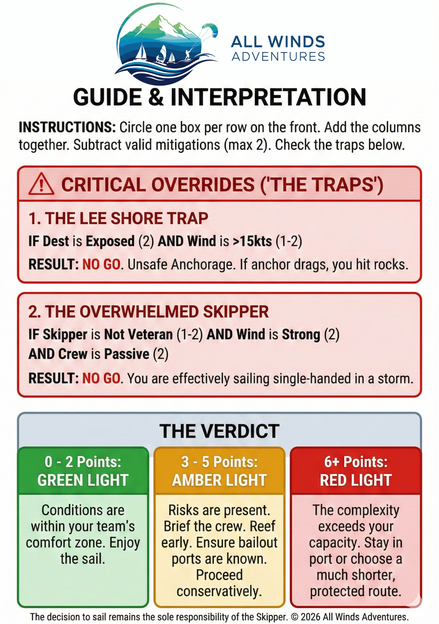
All Winds Skipper Checklist (to Download)
Good seamanship is about preparation. This downloadable Skipper’s Cheat Sheet condenses our best coaching advice into a single page.
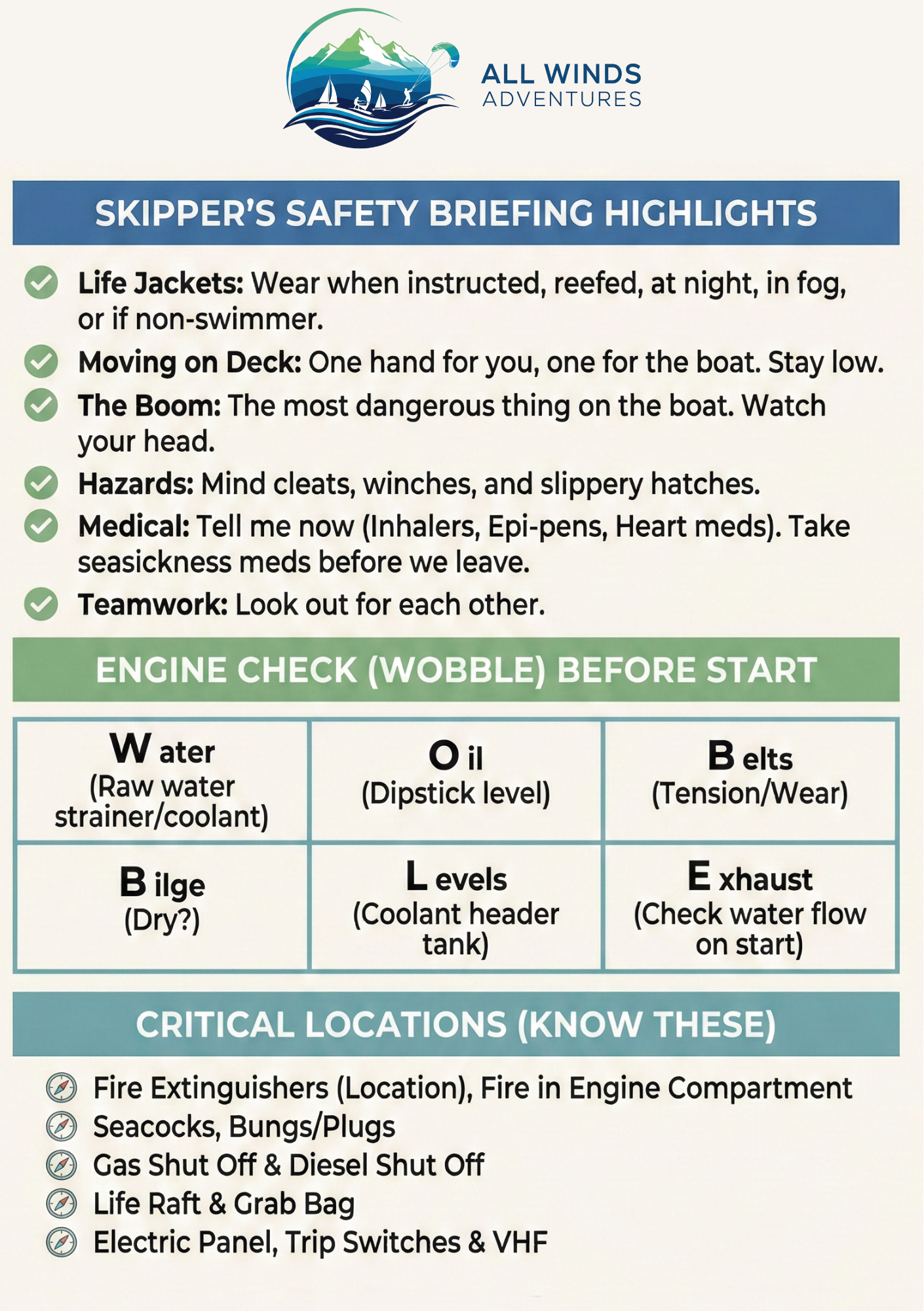
✅ Crew Briefing Script (What to say to your guests).
✅ VHF Radio Template (What to say to the Port Authority).
✅ Pre-Departure Checks (What to check before you drop lines).
Print it. Laminate it. Use it.
How to save this card:
Desktop: Right-click on each image and select "Save Image As..." to download.
Mobile: Long-press on the image and select "Add to Photos" or "Download Image."
Print Settings: For best results, print double-sided on A5 cardstock and laminate for waterproofing.
Need a durable copy? We have professionally printed, waterproof versions of this card available for our charter guests. Contact us to request a hard copy for your next trip.
⚠️ Skipper's Disclaimer: This tool is a for reference only. It does not replace official weather forecasts, nautical charts, or the Skipper's own judgement. The decision to leave port and the safety of the vessel and crew remain the sole and exclusive responsibility of the Skipper.
© 2026 All Winds Adventures.
Theory Refresher
The Pre-Charter "Brain Check"
Passed your exam a few months ago? It’s time to dust off the cobwebs. Sailing knowledge is "use it or lose it." When you are the Skipper in Command, you don't have time to Google "What does a white light over a red light mean?" while a ferry is bearing down on you at 20 knots.
We built this Skipper's Revision Tool as a quick, low-stress way to test your memory on the essentials: Lights, Shapes, Sound Signals, and the Rules of the Road.
How to use this tool:
🧠 Revision Quiz: Tap the cards to flip them. If you hesitate for more than 3 seconds, you need to brush up!
⚙️ Prop Walk: A visual reminder of which way your stern will kick in reverse (crucial for Med mooring).
📋 Cheat Sheet: A quick-reference list of the "must-know" rules.
Category
Question Loading...
👆 Tap to Flip
Answer
Note
1 / 10
Stern Kick Predictor
Check rotation (Forward Gear).
⬅️
STERN KICKS PORT (Left)
⚠️ Skipper's Warning: Don't trust the Charter Papers! Listings are sometimes wrong. Always do a "kick test" (quick burst of reverse) while tied to the dock to confirm direction before leaving.
-
5 Short Blasts"I am unsure of your intentions." (DANGER)
-
Port Side (Red)Give way to vessel on your Starboard side.
-
Windward BoatAlways gives way to Leeward boat.
-
Anchor BallBlack ball displayed forward during the day.
-
RefuellingClose all hatches and ports before starting.
Explore your Cruising Ground
Use this interactive chart to get a feel for the Mediterranean's waters. Whether you are curious about the approach to a specific marina or want to spot the lighthouses along your planned route, this explorer gives you a direct window into OpenSeaMap’s global nautical database.
Pro Tip: Zoom into the Dalmatian coast or the Greek islands to see local seamarks and harbour details. It's the perfect way to start "visualising" your trip before you even step on board!
(Note: This chart is for planning and dreaming only—always use official, up-to-date charts for actual navigation.)
All Winds Navigators Calculator (Planning)
↔ Swipe to view full calculator on mobile
All Winds Adventures Navigator’s Planning Calculator
Master the elements. Plan your passage like a pro.
Whether you are planning a Mediterranean cruise or preparing for your Yachtmaster, Coastal Skipper, or Day Skipper theory exams, this tool helps you account for the "real world" forces of tide, wind, and magnetism.
Instead of just knowing where you want to go, this calculator tells you exactly where to point the bow to get there.
What this tool calculates for you:
True Track (COG): The actual path you want the boat to follow over the ground.
Course to Steer (CTS): The heading you must maintain to counteract tidal stream and leeway.
The "Cadbury’s" Conversion: Automatically applies Variation and Deviation to give you a final Compass Heading.
SOG & ETA: Your speed over the ground and estimated travel time, accounting for the "push" or "pull" of the tide.
How to Plan Your Leg
1. Enter Your Coordinates: Input your Departure and Destination using standard Degrees and Decimal Minutes.
2. Add Your Boat Speed: Input your intended speed through the water (your log speed).
3. Account for Tide (Set & Drift): Check your tidal atlas. Enter the Set (the direction the water is moving toward) and the Drift (the speed of the current). Note: For Mediterranean planning, you can leave these blank.
4. Factor in the Wind: Enter your estimated Leeway (e.g., 5°) and select which side the wind is on. The tool will "point you up" into the wind to compensate.
5. Apply Local Magnetics: Enter the Variation from your chart and your boat’s Deviation card values.
The Result: The calculator provides your final Compass Heading in bold red—this is the exact number to give your helmsman.
Perfect for Theory Students
Studying for your RYA or national sailing exams? Use this tool to check your manual "Course to Steer" plots.
Step 1: Complete your CTS plot on the training chart using your plotter and dividers.
Step 2: Plug the same data into this calculator.
Step 3: Compare your results! It’s the ultimate way to verify your math and ensure you've mastered the "Variation West, Magnetic Best" rules.
⚓️ Disclaimer
This calculator is provided as a planning aid for educational and informational purposes. Electronic tools should never replace traditional navigation skills or sound seamanship. Always verify your results on a physical chart and maintain a proper lookout. Navigation and the safety of the vessel remain the sole responsibility of the skipper.
© 2026 All Winds Adventures.
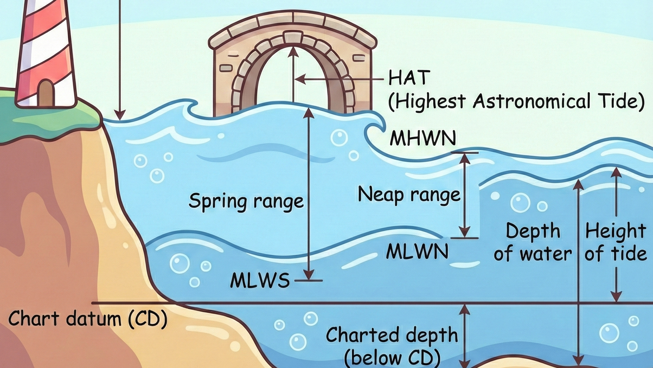
Rule of 12ths Calculator
The Rule of 12ths
The Rule of 12ths is a standard navigation tool used to estimate intermediate tidal heights between High Water (HW) and Low Water (LW) for semi-diurnal tides. It assumes a roughly six-hour tidal cycle following a predictable, symmetrical curve.
The Rule of 12ths Table
The total tidal range (difference between HW and LW) is divided into 12 equal parts. The height changes each hour as follows:
1st Hour1/12th of the total range1/12th
2nd Hour2/12ths of the total range3/12ths (1/4)
3rd Hour3/12ths of the total range6/12ths (1/2)
4th Hour3/12ths of the total range9/12ths (3/4)
5th Hour2/12ths of the total range11/12ths
6th Hour1/12th of the total range12/12ths
Rule of 12ths Calculator
Estimate tidal height between High and Low water.
Total Tidal Range: 3.0m
⚠️ Tide flows fastest during Hour 3 & 4
Anchor Scope Calculator
The Anchor Scope Calculator
The Golden Rule: Depth + Freeboard x Scope.
Dragging an anchor is one of the most stressful parts of a first charter.
Good seamanship isn't just about dropping the hook; it’s about ensuring you have enough "scope" (the ratio of chain length to the vertical distance from the bow to the seabed) to keep the pull horizontal.
How to use this tool:
Water Depth: Enter the depth shown on your chart or depth sounder
Bow Height (Freeboard): Do not forget to add the distance from the waterline to your bow roller (usually 1.0m to 1.5m on most charter yachts)
Select Conditions:
Lunch Stop (3:1): For short stays in calm, protected bays.
Overnight (5:1): The standard for a safe night's sleep in a moderate breeze
Storm (7:1): Use maximum chain when the wind is gusting, or the sea state is rough
Skipper's Tip: Always do your "WOBBLE" engine checks before a long leg and ensure your anchor alarm is set once you are settled
Anchor Scope Calculator
Don't Drag. Calculate your chain.
5.0m
1.5m
*Distance from water surface to bow roller.
REQUIRED CHAIN LENGTH
19.5 m
(5.0m Depth + 1.5m Bow) x 3 Scope
Always set anchor alarm. Snubbers recommended.
The Solid Set: Quick Guide
Spot Selection: Choose a sheltered location that is not a lee shore, prioritising a bottom with sand or mud for the best holding.
The Approach: Approach your selected spot into the wind or tide, whichever is stronger.
The Drop: Stop the boat and drop the anchor to the seabed, ensuring you avoid seagrass, rocks, or coral.
Laying Chain: Let the boat drift or gently engage reverse gear to lay your chain along the seabed.
Setting: Once you have laid out almost as much chain as required for your depth, let the boat sit back against the chain until it is straight.
Digging In: Gently put the boat in reverse to set the anchor, then gradually increase revs to dig it in.
Monitoring: Take transits to ensure you are staying put; if staying overnight, apply significant pressure in reverse for peace of mind.
Final Step: Use a snubber to protect the windlass and reduce noise.
Engine Checks (WOBBLE)
The W.O.B.B.L.E. Engine Check
Prevention is Better Than a Tow
Before you untie the lines and head for that perfect anchorage, your most critical piece of safety equipment is the one sitting under the cockpit sole: the engine. Modern charter yachts are reliable, but a simple mechanical failure can quickly turn a relaxing holiday into a stressful salvage situation
At All Winds Adventures, we teach our skippers the W.O.B.B.L.E. method — a professional-grade pre-start sequence designed to catch 90% of common engine issues before they happen
Water: Check the raw water strainer for debris and the internal coolant levels
Oil: Use the dipstick to verify levels and look for signs of "milky" oil (a sign of water ingress)
Belts: Check the alternator and pump belts for correct tension and signs of black dust/wear
Bilge: A dry engine bilge is the primary indicator of a healthy cooling and fuel system
Levels: Ensure the coolant header tank is at the correct level
Exhaust: Once started, verify a healthy flow of cooling water from the exhaust.
Whether you are a rookie or an experienced sailor, performing these checks every morning is the hallmark of a Skipper in Command. It reduces the risk of mechanical failure and ensures your crew remains safe while exploring complex waters.
The W.O.B.B.L.E. Engine Check
Perform these six essential checks every morning before starting the engine.
W
Water
Check raw water strainer and coolant.
O
Oil
Check dipstick level and color.
B
Belts
Check for tension and wear.
B
Bilge
Ensure the engine bilge is dry.
L
Levels
Check coolant header tank.
E
Exhaust
Verify water flow upon start.
Pro Tip: A dry bilge is the first sign of a healthy engine.
All Winds Logbook Generator (Logging)
Once the sails are dropped and the anchor is set, use our analyser to turn your raw data into a professional logbook ready for your next certification.
All Winds Adventures Logbook Analyser
Keeping an accurate record of your miles and experiences at sea is a vital part of any sailor's journey. Whether you are building miles for future certifications or simply want a beautiful record of your holiday, our analyser turns your raw data into a professional, printable crew logbook.
How to Use the Tool
📥 Download the Template.
Click the Template button below to download our optimised Logbook. You can use this file offline in Excel, or upload it to Google Sheets to update your logs online during coastal passages.
📝 Log Your Journey
Record your hourly fixes, engine hours, and weather observations. The template handles the technical calculations, leaving you plenty of room in the "Observations & Remarks" column for the details of your trip.
💾 Save as CSV
Once you are ready to generate your formal logbook, ensure your file is saved or exported as a CSV (.csv) file.
▶️ Analyse & Print
Upload your CSV using the tool below and click Analyse. The tool will calculate your trip distances, track your engine hours, and format your coordinates to professional maritime standards.
🖨️ Create Your PDF Click Print / Save PDF.
Our tool is designed to provide a clean, landscape A4 printout, perfect for a physical logbook binder.
Important Notes
Coordinate Entry: To ensure accurate distance calculations, please enter your Latitude and Longitude in the DDMM.mm format (e.g., 4331.68 for 43° 31.68'). The analyser will automatically format these for the final printout.
Engine Hours: The tool will automatically calculate "Trip Engine Hours" by finding the difference between your lowest and highest recorded readings.
Disclaimer: This logbook tool has been developed with the best intentions to provide a helpful resource for the sailing community. However, All Winds Adventures cannot accept any responsibility for errors, omissions, or problems that may arise from its use. Navigation and logging remain the responsibility of the skipper. We reserve the right to make changes and improvements to this tool at any time.
© 2026 All Winds Adventures.
Need a Skipper-Friendly Yacht?
Don't gamble on a random internet listing. We have access to 5,000+ professionally managed yachts via Nausys and Booking Manager.
Tell us your experience level, and Dave & Karin will personally find you a 'Skipper-Friendly' yacht in a safe sailing area.
Find My First Boat
Your Charter Wishlist
Ready to take the helm? Whether you want to sail our flagship All Winds or need us to find your perfect match, let’s start planning your adventure.
Please complete this form, and we will send you an offer for a number of boats to suit your needs. If you wish, we can then arrange a video or phone call to discuss your options and nail down your perfect boat.
Don’t worry if you’re unsure about the exact features you want. If you require further information about any of this, leave a note in the “further information” box, and we will contact you to help you decide on exactly what you need. If you have questions, don’t hesitate to contact us.
Frequently Asked Questions (FAQs)
Can I charter with a RYA Day Skipper qualification?
Yes. Most Mediterranean charter companies (Croatia, Greece, Italy) accept the RYA Day Skipper or an ICC (International Certificate of Competence). However, the legal requirement is only half the battle. We recommend that "Day Skippers" gain a few additional miles as active crew or join a Coaching Charter to build the confidence needed to handle a 45ft yacht in a crowded marina.
What is easier: anchoring or docking?
Technically, anchoring is easier because you usually have more space and fewer obstacles. Docking—specifically Mediterranean "stern-to" mooring—requires precise throttle control, coordination with the crew, and management of crosswinds in tight quarters. However, while docking is harder to execute, anchoring is harder to monitor because you must ensure the anchor stays "set" throughout the night.
Do I need a bow thruster for my first charter?
A bow thruster can be a helpful aid, but it should never be your primary tool for docking. We recommend trying to complete your manoeuvres without it, using the thruster only as a "safety net" if the bow begins to stray.
Why technique beats technology:
Reliability: Bow thrusters have small electric motors that can easily overheat or burn out if used continuously.
Power: In a strong crosswind, a thruster often lacks the power to hold the bow against the wind; good steerage and throttle control are far more effective.
Hazards: Be extremely careful when using the thruster near mooring lines or lazy lines; they can be sucked into the tunnel, leading to a fouled prop and an expensive diver's bill.
How do I calculate anchor scope?
Multiply the total depth (water depth + bow freeboard) by the required ratio. We recommend starting with a scope of 5:1 and letting more out if you are worried about holding and taking some in if swing range is an issue, and you are confident in the holding. Some people use the following rule, but when anchoring (as with many things), it's better to be safe than sorry. Remember, if using rope instead of chain you need a larger scope.
Rule of thumb used by some people: 3:1 for lunch, 5:1 for overnight, and 7:1 for storms.
What is the Rule of 12ths?
It is a method for estimating tidal heights in semi-diurnal tides. It assumes a 6-hour cycle where water rises or falls in 1/12th increments.
How do I manage my batteries while at anchor?
Modern yachts have separate "Engine" and "Domestic" battery banks to ensure you can always start the motor. However, large consumers like the fridge and electric heads can drain the domestic bank quickly. Unless your charter boat has ample solar and a large battery bank, we recommend running the engine for an hour in the morning and evening to top up the charge. Keep an eye on the voltmeter on the switch panel—if it drops below 12.2V, it’s time to charge.
Skipper’s Tip: To save significant power, switch off the fridge at night. It will stay cool enough until morning, and your batteries will thank you.